Grassi Lakes is a beautiful Kananaskis hike with views of Canmore, a gorgeous waterfall, and two stunning aquamarine glacial lakes.
There are two trails leading to the lakes. One is steeper and more difficult while the other trail is on a gravel road with gradual incline but lacking the views.
If you are new to hiking this is one of the best trails around Canmore and an easy day hike from Calgary.
Summer 2018 was my summer of hiking with my sister! I stayed with her in Calgary and we planned weekly hikes such as Johnston Canyon and Ptarmigan Cirque trail.
Plus we took a mini-vacation to Jasper National Park and drove one of the top scenic drives in the world with a stop at Parker Ridge Trail to stretch our legs and hike to a panoramic glacier view.
Read on and you’ll see why Grassi Lakes turned out to be one of my favourite Canmore hikes in summer. And it’s also a fun winter hike too.
Jump To Sections In This Article:
Grassi Lakes Canmore Hike


Grassi Lake shimmers turquoise aquamarine shades like a jewel
It you are up to doing two hikes I suggest doing the Grassi Lakes hike first then grab lunch in Canmore, and hike the Grotto Canyon trail afterwards.
Although these are two completely different hikes in Kananaskis Country you’ll find both quite easy and suitable for all ages.
Grassi Lakes trail seasonal closure
Grassi Lakes Interpretive (harder trail) is closed during winter season due to icy conditions. The easy trail remains open year round.
Find the latest on closures and trail conditions at Alberta Parks website.
With wintry conditions at Grassi trail you should bring additional gear to help gain traction on the hiking trail.
On a December hike I wore ice cleats and managed all right, but micro spikes would probably be the best choice on the icy trail, or crampons when there’s packed snow and ice.
I used crampons when I hiked Rawson Lake trail in Kananaskis and they helped immensely.
When there is more snow you can snowshoe to Grassi Lakes.


The more difficult trail is closed during winter due to ice flows, but the easy trail is open


Wear ice cleats, microspikes, or crampons while hiking in snow and ice
Two trails at Grassi Lakes
- Upper Grassi Lakes Trail = easier route – to the right approx 100 meters up the trail
- Grassi Lakes Interpretive Trail = more difficult route – to the left approx 100 meters up the trail
Upper Grassi Lakes Trail is the easier route. Too easy if you are a hiker. Trust me, you don’t want to take this easier trail if you are reasonably fit.
When you take the Upper Grassi Lakes Trail you will miss out on some exceptional views!


Grassi Lakes Canmore hiking trail sign at the trailhead in Kananaskis
There is a gradual incline on the gravel road with no steps or difficult areas.
Anyone with difficulty climbing up or down steep steps, or people with young children may want to take this easier route both up to Grassi Lakes and back down.


Upper Grassi Lakes Trail – the ‘easy’ trail is a gravel road
From spring through summer and early fall there are wildflowers along the Upper Grassi Lakes trail.
This is a great hike if you are just getting into doing outdoor activities and want an easy pace with a big payout of gorgeous turquoise lakes.


Wildflowers at Grassi Lakes Canmore hike in Kananaskis Country
The more difficult trail is referred to as Grassi Lakes Interpretive Trail and while it does include some steep areas it is not a difficult hike.
Anyone with regular mobility should have no problem doing this trail.
As with any activity the key is to pace yourself. Do not try to keep up with other people, go at your own pace and take breaks as necessary.


Grassi Lakes hike in Canmore Alberta – Kananaskis Country
Always a great excuse for a break when you see stunning views or a bench. It would be a shame if someone made a bench and no one sat on it, right?


Bench made from fallen trees along the trail in Kananaskis Alberta
While Grassi Lakes Interpretive Trail can get very busy during beautiful summer days, if you go mid-week you will encounter fewer crowds.
The volume of hiker traffic does decrease a bit because of the other easier trail to the aquamarine lakes.
A lot of folks will do the more difficult hike up to the lakes and take the easier route back down. This helps to alleviate some congestion along the trails.


Grassi Lakes hiking trail waterfall


Staircase beside the waterfall is quite steep but there are railings
Which hiking route is best?
We took the more difficult trail on the way up to Grassi Lakes and returned via the easier route.
Be sure to take the Grassi Lakes Interpretive Trail (more difficult hike) for the views of the town of Canmore and their water reservoir plus you pass right by a huge waterfall on the this trail. All of these sites are missed when you take the Upper Grassi lakes Trail (easy trail) along the gravel path.
If you have small children or people with limited mobility the best route will be the easy trail.


View from the trail overlooking Canmore and Rundle Canal


Grassi Lakes Canmore hiking trail with two gorgeous glacier fed lakes
Why is it called Grassi Lakes Trail?
It is thanks to Lawrence Grassi that we have this trail. Mr Grassi emigrated to Canada from Europe and worked as a miner in Canmore Alberta starting in 1916.
Throughout his time in the region he earned recognition from the Alpine Club of Canada, Canadian Hosteling Association, the national park system, the people of Canmore, and the Canadian government for his extensive work on the trails in the national parks of Alberta and British Columbia.
Lawrence Grassi enjoyed the mountains and participated in making the mountains around Canmore a better place for hikers and outdoor enthusiasts.
Clearly he found something he loved to do and we are fortunate to continue to enjoy the fruits of his labor.


Lawrence Grassi tribute posted at along his namesake hiking trail in Kananaskis
What makes the Grassi lakes so colorful?
Grassi Lakes beautiful turquoise to aquamarine color is due to the source of the water supply. Rock flour, also known as glacial flour, is present in the lakes.
The source of water for Grassi Lakes is the Spray Lakes Reservoir from the Spray River which is a tributary of the Bow River. The Bow River originates from Bow Lake which is fed from the Bow Glacier.
READ MORE: Bow Summit Peyto Lake Trail Icefields Parkway Banff


Grassi Lake Canmore hike with pristine turquoise glacial waters
What is rock flour or glacier flour?
As glaciers erode a fine powder of rock silt is created by rocks grinding against one another. This powdery rock flour travels along the waterways created by the glacial melt waters.
Each glacier has qualities and rock formations that create a special blend of glacier flour unique to that particular region.
Peyto Lake is a fine example where you can see the intense color of the lake as well as the shallow water flowing from the lake.
The color of glacial fed lakes is amazing. The color changes with amount of rock flour and other silt floating in the water.
Read now: 5 Awesome Glacial Lakes in the Canadian Rockies
The Canadian Rocky Mountains rock flour may contain fine particles of limestone, sandstone, shale, and other sedimentary rock. The United States Rocky Mountains are primarily igneous and metamorphic rock and contain mostly granite and gneiss.
You will find there are more glaciers in the Canadian Rocky Mountains compared to the United States Rocky Mountains. In addition the Canadian Rockies are more rugged and jagged in appearance.
If you want much more detailed information on why glacier fed lakes are turquoise I highly recommend reading Scientific Explorer’s blog post here.


Grassi Lakes Trail map


Grassi Lakes Trailhead parking area
Grassi Lakes Hike Info
Type of hike
Out and back
Distance
3.8 km (2.3 miles) round trip
Elevation gain
173 m (568 ft)
Time
Allow 1 hour to 90 minutes
Difficulty
Both trails are easy, one is super easy :)
Best time to hike
June through September is popular for summer hiking season. The harder trail is closed during winter while the easy trail is open year round.
Weather in the mountains is often unpredictable. Bring layers and cold weather clothing options.
Are dogs allowed on Grassi Lakes hiking trail?
Yes, but dogs must be on leash at all times
Facilities at trailhead
Trash and recycle bins, pit toilets


View of Canmore and the mountains from Grassi Lakes trail
Directions to Grassi Lakes trailhead
- From Calgary take the Trans-Canada Hwy 1 West (signs for Banff) approx 90 km (56 miles)
- Take exit 93 towards Three Sisters Parkway/Bow River Campground
- Continue on Three Sisters Parkway/AB-742 for approx 8 km (5 miles)
- Turn LEFT onto Ken Ritchie Way and continue 1.3 km (.8 miles) to Grassi Lakes Trail parking area


Rock climbers at Grassi Lakes rock climbing area


Grassi Lakes rock fall hazard map and rock climbing, trail boundary info


Waterfall at Grassi Lakes Trail Canmore hike
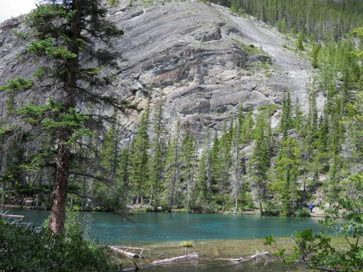

First glimpse of the lake
Save it to Pinterest!


Enjoy hiking in Kananaskis!
Jo Harmon
Sunday 14th of October 2018
Amazing place and great article of it's history. Pictures are beautiful.
Susan Moore
Sunday 14th of October 2018
Thank you Jo! I enjoy these type of hikes where there is an element of historical information provided. It is fortunate that Lawrence Grassi put so much time and effort into making this hike available to future generations. The colors of the lakes are remarkable and mesmerizing to see in person. Cheers, Susan