Fullerton Loop trail near Bragg Creek in Kananaskis Country is an easy day hike if you are driving from Calgary. What I love about this trail:
- Beautiful Elbow River views
- The elevation gain gives me a decent workout
- There’s plenty of parking at the trailhead
Fullerton Loop Trail Kananaskis
Looking for good solo hikes near Calgary I found Fullerton Loop on the AllTrails app. I wanted to do two hikes so I chose Fullerton for the morning hike.
A short drive to Bragg Creek for lunch. Followed up with a hike at Brown Lowery Provincial Park on the way back to Calgary.
What a wonderful way to spend a day in beautiful Kananaskis Country Alberta.
READ now: 5 Easy hikes in Kananaskis


View of Elbow River from Fullerton Loop hiking trail


Butterflies enjoy the warm sunshine on Fullerton Loop trail
Fullerton Loop is open year-round and it’s a nice winter hike with ice cleats, microspikes, or crampons. When there is enough snow Fullerton is a good snowshoe trail.


Parking lot at Fullerton Loop trailhead in Kananaskis AB
Trailhead and parking area for Fullerton Loop trail
The parking lot is on Ranger Creek Road, just off of Hwy 66.
There is parking on both sides of the highway and it’s worth walking across to view the Elbow River at Allen Bill Day Use parking area.
At the trailhead there are washrooms and garbage and recycling bins as well as a map of the trail.
Before starting any hike I like to take a photo of the trail map in case I want to review the trail route while I’m hiking.


Fullerton Loop trail map
Getting to the loop portion of the trail takes around 20 minutes. Look to the right for views of the Elbow River and once you get into the forest area the trail crosses a stream.


Stream near the beginning of Fullerton Loop hike


Beginning the hike at Fullerton Loop trail
Choose your route
Once you get to the loop portion of the trial you will see a set of wooden stairs to the left and regular trail to the right. This is where you choose which direction to do the loop.
Right is easier and left (stairs) is more difficult.
If you take the stairs there is quite a sharp incline and pretty much all of the elevation gain is at this portion of the trail.


Stairs at Fullerton Loop trail are the more strenuous route


Wear microspikes or ice cleats for wintry conditions on the trail
Some people prefer to take the right side of the trail and avoid the quick elevation gain.
Also this leaves the views for the latter portion of the hike rather than near the beginning.


Uphill portion of Fullerton Loop trail
I prefer the opposite. I enjoyed the workout at the beginning of the loop and took it easy the rest of the hike.
This is also why I enjoyed Ptarmigan Cirque hike so much.


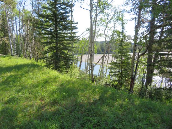
View of the valley and mountains
Enjoy views of the Elbow River and mountains in the background from Fullerton loop.
Much of the hike is through the forest. There are a meadows with wildflowers.


Forest at Kananaskis Fullerton Loop trail


Wildflowers along Fullerton Loop trail in Kananaskis Country
Fullerton Loop is a busy trail so you’ll likely see other hikers along the way. It’s a great trail for hiking alone. There is bench in a shaded area which would make a nice spot for a picnic lunch.


Shaded bench at Fullerton Loop trail
Halfway mark along Fullerton Loop
Shortly after the bench you will see a sign marker for Fullerton Loop pointing to the right.


Fullerton Loop trail marker
A map of the trail is located roughly at the halfway mark of Fullerton Loop.


Halfway mark on the map at Fullerton Loop hike
Another map of Fullerton Loop trail is a little further along the trail. The map (shown below) is from before the trailhead changed to its current location.
Before the 2013 flood the Fullerton Loop trailhead began on the Allen Bill Day Use parking lot and crossed under Hwy 66.


Fullerton Loop hiking trail map
It took me 2 hours to complete the hike with a few stops to take in the views and several stops taking photos along the way.
Another nice stop in the area is Elbow Falls, less than 10 km (6 miles) from Fullerton Loop. It’s a beautiful place to enjoy the waterfall and have a picnic lunch after your hike.


Wildly blooming Alberta wild roses
Visitor info Fullerton Loop Trail Kananaskis
Location of trailhead
Alberta Hwy 66 near Bragg Creek Kananaskis Alberta T0L 0K0
Facilities
- Washrooms
- Garbage bins
- Recycling bin
Type of trail
Loop
Hike length
6.8 km (4.2 miles) including approx 2 km (1.2 miles) to get to the loop portion of the trail
Elevation gain
213 m (692 feet)
How long to hike Fullerton Loop?
Allow 1.5 to 2.5 hours
Are dogs allowed on Fullerton trail?
Yes Fullerton Loop trail is dog friendly! Dogs must be on leash at all times


You’ll see lots of dogs on Fullerton Loop trail
Getting to Fullerton Loop from Calgary
Depending on what part of Calgary you are in the options are:
From North Calgary
- Take Hwy 201 Stony Trail to Trans-Canada Hwy 1 West.
- Take exit 161A for Hwy 22 South toward Bragg Creek.
- Follow Hwy 22 for 21 km (13 miles) and turn right onto Hwy 66.
- Continue for 11 km (7 miles) and turn right onto Ranger Creek Road.
From downtown Calgary
- Follow 6 Avenue to Bow Trail SW and continue on Bow Trail SW to the Crowchild Trail S exit.
- Take Crowchild to exit 1 Glenmore Trail West.
- At the roundabout take the 3rd exit to Hwy 22 South toward Bragg Creek.
- Follow Hwy 22 for 21 km (13 miles) and turn right onto Hwy 66.
- Continue for 11 km (7 miles) and turn right onto Ranger Creek Road.
From South Calgary
- Get on Hwy 201 Stony Trail to Hwy 22 towards Bragg Creek.
- Continue west on Hwy 66 for 11 km (7 miles) and turn right onto Ranger Creek Road.
Enjoy hiking Fullerton Loop trail in Kananaskis Country, one of the best places for hiking in Alberta.

Starting out at Fullerton Loop hiking trail – Elbow River view
Jeff Chong
Monday 7th of June 2021
Such a thorough review! Thanks